Many of the old areas, back alleys and side streets which were recorded in the various censuses, Civil Registration records and church and chapel registers, have long since swept away during the slum clearances and redevelopment of the early to mid 20th century, or have disappeared beneath the many car parks and new road developments of the second half of the last century.
Perhaps the most significant development relating to Ilkeston’s street system was the construction of the town centre relief road, Chalons Way, during the early 1990s which resulted in the destruction and clearance of many streets and houses.
This section is designed to assist the researcher in their quest to locate the approximate or even exact birthplace or residence of a person or an ancestor. This contains information relating to whether these streets or areas still exist at the time of writing or if extinct, can be found relative to the Ilkeston of today.
With the use of a modern street map, this guide and a little leg-work it is relatively easy to locate many of the places mentioned in the records.
Much use has been made of Ilkeston Reference Library’s extensive collection of Ordnance Survey Maps, especially those produced to a highly detailed scale of 1:500 dating from around the early 1880s. Other sources include Maps and Plans of Ilkeston 1588-1885 by Peter Stevenson (published 1975) and The Street Names of Ilkeston by Margaret Brown (published 1983).
Extinct – originally adjacent to Club Row and Mount Street.
Bell’s Yard
Extinct. Formerly off Evans Row and named after the keeper of the Traveller’s Rest public house, William Bell.
Belvoir Street
Extant.
Bethel Street
Extinct.
Bindage Meadow Road
Ancient name for Longfield Lane.
Blake Street
Extant.
Boat Inn
also known as The Jolly Boatman.
Botany Bay
Extinct area now occupied by Bridge Street, Cotmanhay. So named due to its isolated position in relation to Ilkeston proper. (Botany Bay was the first convict settlement in Australia).
Bower Hill
Extinct area east of present Norman Street.
Brewery Cottages
Extant dwellings on Wilmot Street. Adjacent to Bourne Cottages and Spring Cottage public house.
Brewery Row
Extinct dwellings believed to have stood off Burr Lane.
Brick Lane
Extinct.
Bridge Inn (Awsworth Road)
Former public house, now site of the ‘Canal Vue’ Nursing Home.
Bright’s Terrace
Extinct thoroughfare linking Gladstone Street and Extension Street.
Brook House (Heanor Road)
Extinct dwelling possibly standing towards the lower end of Heanor Road.
Brook Street
Extant.
Browns Yard (Burr Lane)
Extinct.
Brussells Terrace
Extant in part.
Burns Street (off The Market Place)
Extant.
Burr Lane
Extant and probably the oldest street in the town. Contains many original Victorian dwellings. The name may originate from the Anglo-Saxon word Burgh meaning fortified settlement.
Burrow’s Lane
see Burr Lane.
Byron Street
Extant though partly cleared during development of Chalons Way.
Extinct area lying along the Erewash Canal between Awsworth Road and Station Road.
Carr Street
Extinct. Formerly off lower Bath Street.
Chain Row
Row of dwellings which once stood opposite the Three Horse Shoes pub at the top end of Derby Road, demolished 1980.
Chapel Lane
see Chapel Street.
Chapel Street
Extant though partly cleared during development of Chalons Way. Lower Chapel Street contains a number of original Victorian buildings.
Chapel Street East
see Lower Chapel Street.
Charlotte Street
Extant.
Chaucer Street
Extant.
Chrichley Street
Extant.
Coal Pit Lane
Former name for Awsworth Road.
Club Row
Extinct terrace of dwellings lying behind the west side of Bath Street. Site now occupied by Club Row car park.
Commercial Terrace
Extinct terrace of dwellings off Awsworth Road.
Common, The
see Ilkeston Common.
Common Gardens
Extinct area of the Common turned over to allotments following the enclosure of the common at the end of the 18th century.
Cotmanhay
Extant area north of Ilkeston proper. In more ancient times only the area north of the present Church Street was known as Cotmanhay. The name probably derives from the Anglo-Saxon cott mann haeg – meaning the enclosed land of a cottager.
Cranmer Street
Extant.
Cricket Ground
Extinct area originally behind the former Anchor Inn off Market Street.
Critchley Street
Extant.
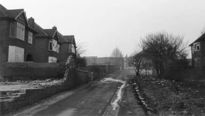
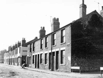
Chapel Street leading to Lodge Row, about 1968 (Peter Stevenson)
Extinct area at rear and west of Bath Street and opposite Chapel Street.
Deakin Row
see Daykin’s Row.
Derby Road
Extant – previously known as Moorbridge or Moorsbridge Lane.
Derby Street
Extant though only partly.
Dicken’s Yard
Extinct and possibly relates to Daykin’s Row.
Dorothy Cottages
Extinct row of dwellings off Pimlico.
Drummond Road
Extant.
Duke Street
Extant.
Durham Ox
Extant public house on Durham Street.
E
Earl Place
Extinct area off lower Bath Street.
East Street
Extant and containing several original 18th and 19th century dwellings.
Ebenezer Street
Extant.
Essex Street
Extant.
Evans Cottages
Extinct – exact location unknown at present. May relate to dwellings off Evans Row.
Evans Row
Extinct thoroughfare off south side of White Lion Square.
Evans Shops
Extinct – exact location unknown. May relate to dwellings etc on Evans Row.
Extension Street
Extinct street originally off Market Street.
Eyres Gardens
see Ayres Gardens.
F
Factory Lane
Extant.
Field House
Extinct. Formerly the home of Matthew Hobson. Site now occupied by Morrison’s supermarket and modern housing, formerly by South-East Derbyshire College.
Fenns Hollow (Station Road)
Extinct, exact location unknown. The House Ferns Hollow exists at the side of the Canal.
Fishpond Cottages
Extinct dwellings probably lying alongside the Erewash Canal.
Flinders Row
Extinct row of 5 dwellings leading off Chapel Street.
Florence Row / Square
Extinct. Site now occupied by Florence Court off Station Road.
G
Gallows Inn
Extant area lying at the south end of Nottingham Road. Pub of the same name, for a time officially known as the Horse and Groom.
Gladstone Street
Extant though partly cleared during development of Chalons Way.
Graham Street
Extant.
Granby Street
Extant though partly cleared during development of Chalons Way.
Grass Lane
Former name of Norman Street.
Green’s Court
Extinct, originally adjacent to Hunger Hill Yard.
Greens Lane
Extant.
Gregory Street
Extant.
H
Hais Lane
Extinct. Possibly an earlier reference to Hallcroft Road.
Hallam Fields
Extant area containing a number of original Victorian dwellings.
Hallcroft Place
Extinct area later the site of Hallcroft and Gladstone Schools.
Harefields (Derby Road)
Extinct area at the east end of the present Derby Road..
Harrow Hotel (Bath Street)
Extant public house, the Old Harrow or just the Harrow and at one time called the Roundhouse.
Havelock Street
Extant.
Havelock Terrace
Extinct terrace off Chapel Street. Now the approach to a car park.
Heanor Road
Extant.
High Holborn
Extant.
High Street
Extant, but apart from Dalby House (Erewash Museum) contains no original dwellings.
Highfield House
Extant dwelling on Wilmot Street.
Hobson Drive
Extant.
Hope Street
Extant.
Hunger Hill
Extinct area lying between the Needlemaker’s Arms and the local store, formerly the White Cow public house.
Hunger Hill Yard
Extant, though containing few original dwellings.
Harts Yard
Extinct area off Awsworth Road between Slade Street and Springfield Terrace.
I
Ilkeston Common
Extinct area of some 383 acres of open common ground, enclosed circa 1795 and home to a number of scattered dwellings erected piecemeal during the 18th and 19th centuries.
Ilkeston Common Lock
Extinct area lying alongside the Erewash Canal.
Ilkeston Junction
Extant area off lower Station Road – see also Trueman Street. Originally in Nottinghamshire, it was incorporated into Ilkeston in the 1990’s.
Ilkeston Mill Lock
Extinct area around the present Potters Lock.
Ingleside
Extant Victorian dwelling on Wilmot Street.
Ivy Villa
Extant Victorian dwelling on Wilmot Street.
J
Jackson Avenue
Extant.
John Street
Extant.
K
Kensington
Extant area off Nottingham Road and formerly known as Hunger Hill.
Kensington Street
Extant.
King Street
Extant.
Kirk Hallam Hall
Extinct dwelling demolished in 1973.
L
Larklands
Extant area lying south-east of town centre.
Lawn Terrace
Extinct dwellings off Pimlico.
Leahurst (Gregory Street)
Exact location unknown.
Lees Yard
Extinct. Alternative name given to Albion Place.
Lime Street
Extant.
Little Hallam
Extant area south of Ilkeston proper but part of the old Borough.
Little Hallam Lane
Extant.
Lodge Row
Extinct terrace off Chapel Street and adjacent to Flinders Row.
Lord Haddon Road
Extant. Named after Lord Robert Charles John Manners of Haddon Hall.
Lord Nelson Street
Extant – see Nelson Street, Cotmanhay.
Lower Granby Street
Extant.
Lower Grass Street
Extant.
Lowes Yard
Extinct area off west side of upper Bath Street see also Whites Yard.
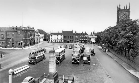
The Market Place (1950s)
M
Market Cottages
Extinct dwellings originally standing between the present Market Inn and Harrow public houses on The Market Place.
Market Place
Extant area in town centre containing several original Victorian buildings.
Market Street
Extant.
Middle Lane
Early/Mid 19th century name given to area later occupied by Charlotte Street, Norman Street and Grass Lane.
Mill House
Extinct dwelling on the banks of the River Erewash.
Mill Street
Extant.
Millfield House
Exact location unknown at present.
Moorbridge Lane
Extant – pre late 19th century name of the present Derby Road.
Moorsbridge Lane
see above. Moor’s or Straw’s Bridge was at the bottom of Derby Road.
Mount Row
Extinct terrace of dwellings adjacent to Club Row. Site now occupied by car park.
Mount Street
Extant.
Mount Terrace
see Mount Row.
Mundy Street
Extant (partly).
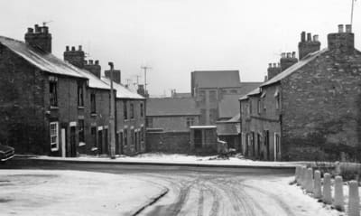
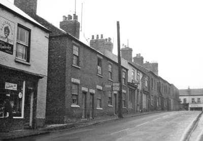
The northern end of North Street, about 1968 (Peter Stevenson)
N
New England
Former name given to Hallam Fields area.
New Street
Former name given to the western end of Station Road.
Norman Street
Extant.
North Street
Cleared during construction of Chalons Way.
Northgate
Extinct street originally off North Street.
Nottingham Road
Extant. Known as ‘The Bridge Lane’ in more ancient times.
Nutbrook Junction Lock
Extinct area at the junction of the Nutbrook and Erewash Canals.
O
Orchard Street
Extant.
Oxford Street
Extant.
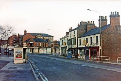
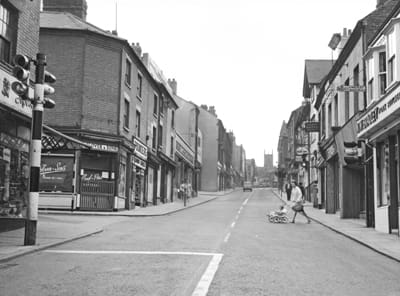
Bath Street / Station Road junction, about 1965 (David Hudson)
P
Park The
A general area east of the town centre and site of the Park Cemetery.
Park Avenue
Extant.
Park Drive
Extant.
Park Road
Extant. Known as ‘The Millfield Lane’ in more ancient times.
Pedley Street
Extant.
Peewit Wharfe
Extinct area originally lying alongside the Nutbrook Canal.
Pelham Street
Extant.
Pimlico
Extant street off the Market Place though containing no original dwellings.
Pinfold Lane
Extinct lane originally running parallel to Stanton Road from the top end of the present Derby Road and down to Little Hallam. The route is now more or less occupied by Dale View and Derbyshire Drive.
Potteries, The
Extinct area lying alongside the Erewash Canal near to Awsworth Road.
Pottery, The
see Potteries.
Princes Court
Extinct. Originally off east side of Nottingham Road and opposite Hunger Hill Yard.
Q
Queen Street
Extant.
Queens Terrace
Extinct terrace of dwellings to the west and rear of South Street.
R
Red House, The
Extant former private dwelling on Wharncliffe Road.
Regent Street
Extant.
Robey Yard
Extinct, site now occupied by the medical centre on South Street.
Ropewalk
Extant area off lower Station Road.
Rutland Hotel
Extinct hotel and public house at junction of Bath Street and Heanor Road.
Rutland Place
Extinct – location unknown at present.
S
Severn’s Road
see Severns Yard.
Severn’s Yard
Extinct area off High Street.
Shaws Yard
Extinct area between Awsworth Road and Cotmanhay Road.
Sir John Warren
Extant public house on The Market Place.
Slade Street
Extinct. Slade Street was demolished in 1971 and replaced with flats. The site of the street originally lay off North Street and between Station Road and Critchley Street.
Sough Close/s
(pronounced as ‘Suff Close’) – Extinct area around the present Green’s Lock.
Smith Street
Extinct.
South Street
Extant – with Bath Street it was known as ‘The Town Street’ in more ancient times.
Springfield Terrace
Extinct terrace of dwellings.
Springfield Villas (Wilmot Street)
Exact location unknown at present.
St Mary Street
Extant and containing many original Victorian dwellings.
Stanhope Road
see Stanhope Street.
Stanhope Street
Extant.
Stanton Road
Extant – known in more ancient times as Boot Lane and Harrisons Lane.
Station Court (off Bath Street)
Extinct though the entrance and name plate can still be seen opposite the junction of Station Road.
Station Terrace
Extinct area off Station Road. The entrance can still be seen off the junction of Station Road and Chalons Way.
Station Road
Extant and containing many original Victorian dwellings. West end at one time known as ‘New Street’.
Stratford Street
Extant.
Sudbury Avenue
Extant.
Station Road looking towards Bath Street, about 1968 (Peter Stevenson)
T
Taylor Street
Extant.
Thurman Street
Extant.
Toll Bar
Extinct area now occupied by part of White Lion Square. It was the site of the Turnpike’s Toll Gates.
Town Street
Original name given to South Street, Market Place and Bath Street.
Trueman Street
Extant.
Trueman’s Court (South Street)
Extant though only partly.
Trueman’s Row
Extinct terrace of dwellings at the junction of Burr Lane and Albion Place.
Tutin Street
Extinct – originally off Belvoir Street.
Tutton’s Buildings
Extinct – possibly a misspelling of Turton’s Buildings off Belper Street.
U
Union Road
Extant.
V
Vicarage, The
Extant early and late Victorian building. Now a private dwelling off the Lower Market Place.
Victoria Street
Extant.
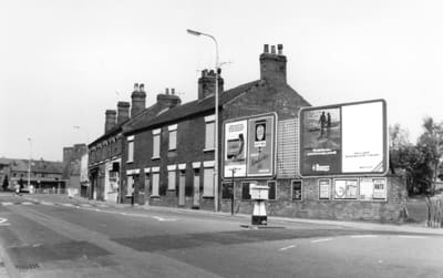
Houses on the north side of White Lion Square, about 1968 (Peter Stevenson)
W
Wakefield’s Yard
Extinct – originally off the south side of White Lion Square.
Weaver Row
Extant path linking South Street with Market Street originally contained many dwellings but containing none today.
Weaver Pool
Extinct. The site of an ancient pond now occupied by the former Ritz Cinema on South Street. The name may have little to do with weaving but may have derived from the word waiffer meaning something belonging to no-one in particular.
Wheatley Row
Extinct terrace of dwellings. Site now occupied by Lawn Road.
White Lion Square
Extant area though much redeveloped during late 20th century, and not a square any more.
Wide Yard
Extinct area off west side of South Street. Roughly opposite Weaver Row.
Wilmot Street
Extant.
Wilton Place
Extant.
Wood Street
Exant.
Whites Yard
Extinct – originally off west side of upper Bath Street. The entrance, though blocked, can still be seen.
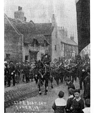
Extracted from the Ilkeston Advertiser 27th July 1962 By Grant Shaw A highlight of Ilkeston life in 1909. Mr David Martin of 29 Green Lane Larklands sent us this photograph of Superintendent Daybell on horseback riding at the head of the parade on Ilkeston’s Lifeboat...
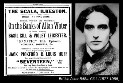
On the Banks of Allan Water By Grant Shaw Beverley Kilby recently gave me some scraps of a 1917 edition of the Ilkeston Pioneer newspaper, and these include the weekly adverts for ‘what’s on’ at the Kings and Scala Cinemas. I was immediately sucked into the rabbit...
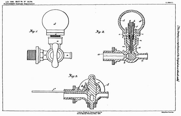
By Jeff Wynch William Fletcher came to Ilkeston from his home town of Southwell to set up as a chemist on Bath Street in 1868. Under the Pharmacy Act of that year, the terms Chemist and Druggist could only be legally used by those who had passed a basic Pharmaceutical...